About this climb
The Rongai Route is Kilimanjaro's best-kept secret. While the Machame and Marangu routes carry thousands of climbers each season, the Rongai sees only a fraction of that traffic — resulting in a genuinely remote, wilderness-quality experience that feels unlike any other route on the mountain.
Departing from near Loitokitok on the Kenya border, the route approaches from the north — the only route on Kilimanjaro to do so. The northern slopes are significantly drier than the southern approaches, meaning less rain in the forest zone and a very different character of vegetation and wildlife. The descent follows the Marangu Route, so every Rongai climber experiences two entirely different sides of the mountain in a single expedition.
Every other Kilimanjaro route approaches from the south or east. The Rongai Route starts near the Kenya border, climbing through the mountain's remote northern face. This means: dramatically drier conditions (far less rain), distinct vegetation zones, a completely different perspective on Kibo's summit cone, and far fewer fellow climbers on the trail.
The remote northern forest on the Rongai Route is one of Kilimanjaro's best wildlife zones. Elephants are frequently encountered in the lower forest. Buffalo, black-and-white colobus monkeys, blue monkeys, duiker, and a remarkable variety of birds are regularly sighted. Because traffic is low, animals behave naturally around the trail.
Ascent via Rongai from the north; descent via the Marangu Route to Marangu Gate on the south-east. This means you see two entirely different faces of Kilimanjaro, two different climate zone sequences, and two very different landscapes. Most other routes ascend and descend the same side of the mountain.
Wildlife on the Rongai Route
The northern forest zone is remote and receives few visitors. Wildlife encounters are frequent, undisturbed, and often extraordinary. This is one of the most significant differences between the Rongai and all other Kilimanjaro routes.
6-day itinerary
-
A long drive from Moshi (approximately 3.5 hours) brings you to the remote Rongai Gate near Loitokitok, close to the Kenyan border. The drive itself is an adventure — winding through Kilimanjaro's foothills with views of the northern face. The first day's hike is gentle, through pristine forest where elephant encounters are common.
-
06:30Depart Moshi for Rongai Gate
~3.5 hour drive north toward the Kenya border. Pass through Kilimanjaro's northern foothills with increasing views of the mountain's untouched northern face.
-
10:30Rongai Gate — register and begin
Park registration at the remote gate (2,000 m). Enter the northern forest immediately — alert for elephants and buffalo from the very first steps.
-
13:00Hot lunch in the forest
Break in the forest as your porters continue ahead. The forest is remarkably quiet — no other groups, just birdsong and the distant sound of your crew's voices ahead.
-
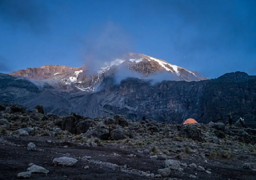
15:30Arrive Simba Camp (2,640 m)
First camp — heather moorland with open views north toward Kenya. Clear days bring views of the Amboseli plains. Dinner, hot drinks, and oxygen saturation check by guide.
- 📍 ~9 km
- ⏱ 3–4 hrs hiking
- ⛰ 2,000 m → 2,640 m
- ⛺ Simba Camp
-
-
A significant altitude gain day with a built-in acclimatization hike to Second Cave before continuing to Third Cave Camp. The northern moorland is strikingly different from the southern heather zones — more open, drier, with wide views toward Kenya and a profound sense of isolation. The "Caves" are not actual caves but distinctive lava overhangs used as shelters.
-
07:00Depart Simba Camp
Ascend through heather moorland with Kilimanjaro's northern slopes rising ahead. The terrain is drier and more open than the southern routes — alien, beautiful, and very quiet.
-
11:00Second Cave (3,450 m) — acclimatization hike
Optional extension to higher ground above Second Cave (~3,600 m) using "climb high, sleep low" technique. Return to the main trail and continue to Third Cave.
-
14:30Arrive Third Cave Camp (3,870 m)
Named for the distinctive lava overhangs nearby. Camp beneath dramatic moorland cliffs with wide Kenya-side views. Altitude monitoring and guide briefing.
-
17:30Rest, dinner & altitude briefing
Altitude effects may begin here. Drink 3–4 litres of water. Your guide monitors oxygen saturation readings and gives the acclimatization briefing.
- 📍 ~12 km
- ⏱ 6–8 hrs
- ⛰ 2,640 m → 3,870 m
- 🔄 Acclimatization hike
- ⛺ Third Cave Camp
-
-
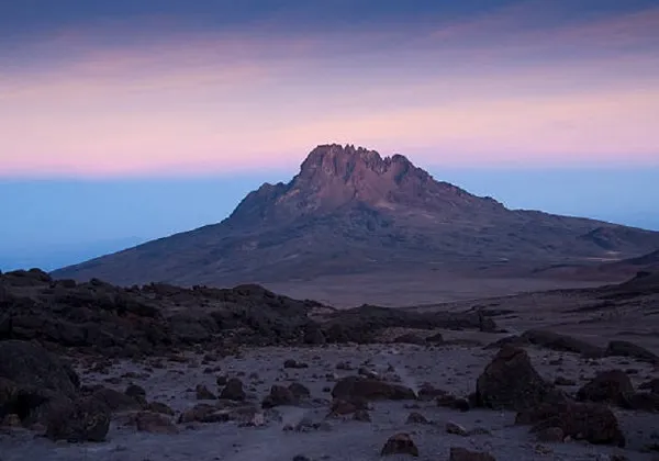
A dramatic day as the vegetation disappears and you cross into the high-altitude desert zone. School Hut (also called Kibo North Camp) sits at 4,750 m on the north-east flank of Kibo — the highest and most spectacular campsite on the Rongai Route, with Mawenzi peak rising to the east and the Kenyan plains far below.
-
07:30Depart Third Cave — enter alpine desert
Vegetation thins rapidly. Rocky volcanic terrain dominates. The air is noticeably thin but the terrain is not technically difficult — just relentlessly upward.
-
11:00Last water point (4,200 m)
Fill all water bottles completely — no water source exists from here to the summit and back to Horombo Hut on the descent.
-
13:30Arrive School Hut (4,750 m)
The highest regular campsite on the Rongai Route. Lunch immediately on arrival, then rest completely. This is 77 metres higher than Barafu on the Machame Route. Extraordinary views of Mawenzi peak.
-
17:00Full summit night briefing & early dinner
Guide runs through the complete summit push protocol: midnight wake-up, layering system, pace strategy, turn-back criteria, and emergency procedures. Bed by 18:30.
- 📍 ~9 km
- ⏱ 4–6 hrs
- ⛰ 3,870 m → 4,750 m
- ⛺ School Hut
-
-
The night everything has been building toward. The Rongai summit push is unique — approaching the crater rim from Gilman's Point via the north-east, with a slightly different summit ridge walk than the southern routes. The views from the summit back over the Kenyan plains at sunrise are extraordinary and different from anything a climber on the southern routes will see.
-
23:00Wake up — begin summit push
Hot tea, biscuits, final layer check. Temperature −10°C to −22°C near the summit. School Hut's higher starting altitude means the gap to the crater rim is slightly shorter than on the Machame Route. Headlamps on. Pole pole.
-
04:30Gilman's Point — Crater Rim (5,681 m)
First light. The Kenyan plains stretch away to the north-east far below. A short rest, then the final walk along the crater rim to Uhuru Peak. TANAPA certificate available here for those who cannot continue.
-
06:00UHURU PEAK — 5,895 m 🏔
The Roof of Africa. Sunrise from the highest point on the continent. The summit views north over Kenya, and east to Mawenzi and the Indian Ocean horizon, are unique to the Rongai climber's perspective. Your guide photographs you. Allow the moment fully.
-
08:00Descent via Marangu Route → Horombo Hut
Descend the southern face via the Marangu descent trail — your first experience of the south side of the mountain. A long but triumphant descent to Horombo Hut at 3,720 m.
- 📍 ~17 km total
- ⏱ 12–15 hrs
- ⛰ 4,750 m → 5,895 m → 3,720 m
- 🏠 Horombo Hut
-
-
The descent via the Marangu Route is one of the most satisfying aspects of the Rongai itinerary — climbers pass through the south-eastern forest zone for the first time, comparing its lush, misty character with the drier northern forest they ascended through. Two routes, one mountain, one expedition.
-
07:30Breakfast at Horombo & depart
Leisurely morning. The hard work is done. Descend through the Marangu moorland zone — softer, greener, and wetter than the northern side you came up.
-
11:00Reenter forest — southern side
Descend into the southern forest. Lush Podocarpus trees, giant ferns, and Impatiens flowers — noticeably more verdant than the northern forest. Colobus monkeys here too.
-
13:30Arrive Mandara Hut (2,720 m)
Final night in the forest. A hot lunch and relaxed afternoon. Optional visit to the Maundi Crater crater rim viewpoint — a 30-minute walk from camp.
- 📍 ~12 km
- ⏱ 4–5 hrs
- ⛰ 3,720 m → 2,720 m
- 🏠 Mandara Hut
-
-
A short final descent through the forest to Marangu Gate, where your official TANAPA summit certificate awaits. The porters' farewell song at the gate is a deeply moving moment that marks the true end of a Kilimanjaro expedition.
-
07:30Breakfast & final porter goodbyes
Unhurried final morning at Mandara Hut. Sign the porter tip register. Say goodbye to each porter and guide individually.
-
08:30Descend to Marangu Gate
2–3 hour walk through the southern rainforest. Easier terrain than the northern forest — a gentle ending to an extraordinary journey.
-
11:30Marangu Gate — certificate presentation
Your official TANAPA Kilimanjaro Summit Certificate. Porters perform their traditional farewell song. Karibu sana — you climbed Africa from the north.
-
13:00Return to Moshi — celebration
Hot shower, rest, and a group celebration dinner. End of all services.
- 📍 ~8 km
- ⏱ 2–3 hrs
- ⛰ 2,720 m → 1,870 m
- 🏨 Return to Moshi
-
Choose your package
All packages follow the identical 6-day Rongai Route itinerary with tented camping on ascent and hut accommodation on descent. The tier affects hotel comfort, guide ratio, and included extras.
- Budget guesthouse Moshi (Day 1 & Day 6)
- All TANAPA park, camping & hut fees
- KPAP-certified lead guide + armed ranger
- All porters & mountain cook
- 3 meals/day + snacks on mountain
- Emergency supplemental oxygen
- Daily pulse oximeter monitoring
- TANAPA summit certificate
- Mid-range hotel Moshi (Day 1 & Day 6)
- All TANAPA park, camping & hut fees
- Dedicated lead guide + assistant + armed ranger
- All porters, cook, waiter & toilet tent
- 3 meals/day + hot drinks + snacks
- Safety oxygen + Gamow bag
- Twice-daily oximeter check
- Airport transfers included
- TANAPA summit certificate
- Boutique hotel Moshi (Day 1 & Day 6)
- All TANAPA park, camping & hut fees
- Private 1:1 guide ratio + armed ranger
- Full porter crew + private toilet + shower tent
- Restaurant-quality meals + full snack bar
- Oxygen, Gamow bag & AED device
- 3× daily oximeter + satellite communicator
- Airport transfers + Moshi cultural tour
- Safari combo pricing available
What's included
- All TANAPA national park entry fees
- Camping fees (3 nights tented) + hut fees (2 nights Marangu descent)
- KPAP-certified professional lead guide
- Armed ranger for the northern forest zone
- Assistant guide (1 per 3 climbers)
- Porters (~3 per climber) + mountain cook
- All mountain meals (3 per day) + water
- Emergency supplemental oxygen cylinder
- Daily pulse oximeter health monitoring
- TANAPA summit certificate at Marangu Gate
- KINAPA rescue fee contribution
- International flights to KIA / JRO airport
- Tanzania tourist visa (~$50 USD)
- Personal travel & evacuation insurance
- Personal hiking gear (rental available in Moshi)
- Sleeping bag −15°C rated (rental available)
- Trekking poles (strongly recommended, rental available)
- Tips / gratuities for guides and porters
- Alcoholic beverages
- Diamox altitude medication (prescription required)
How Rongai compares to other routes
Where the 6-day Rongai Route sits among all Kilimanjaro options:
| Route | Days | Sleeping | Success | Direction | Difficulty | From |
|---|---|---|---|---|---|---|
| Marangu 6-day | 6 | Huts 🏠 | ~80% | South-east | Moderate | $1,850 |
| Machame 6-day | 6 | Tents ⛺ | ~75% | South | Challenging | $1,750 |
| Rongai 6-day ← You are here | 6 | Tents + Huts | ~80% | North ← only! | Moderate | $1,950 |
| Machame 7-day | 7 | Tents ⛺ | ~85% | South | Challenging | $1,900 |
| Lemosho 8-day | 8 | Tents ⛺ | ~92% | West | Challenging | $2,200 |
Best time to climb
The Rongai Route benefits from the northern slopes' drier climate — less rain than southern routes year-round:
| Months | Season | Summit Conditions | Northern Trail | Wildlife |
|---|---|---|---|---|
| Jan – Feb | Dry & clear | Excellent | Dry, good grip | High |
| Mar – May | Long rains | Acceptable | Drier than south | Very high |
| Jun – Oct | Dry (peak) | Excellent | Dry, firm, clear | High |
| Nov | Short rains | Acceptable | Some rain, drier than south | Very high |
| Dec | Dry & cold | Excellent | Dry, firm, clear | High |
Note: The Rongai's northern exposure makes it significantly drier than the Machame or Marangu during the long rains (March–May). Many climbers who want to avoid the wet season but cannot move their dates choose the Rongai specifically for this reason.
Frequently asked questions
-
The Rongai Route is the only Kilimanjaro route that approaches from the north, starting near the Kenyan border. Every other route — Machame, Marangu, Lemosho, Umbwe — approaches from the south or east. The northern approach means: significantly drier conditions (far less rain), completely different vegetation and wildlife (elephants are common), views of Kilimanjaro's rarely-photographed northern face, far fewer climbers on the trail, and a descent via the Marangu Route giving you two entirely different sides of the mountain in one expedition.
-
Prices range from $1,950 (standard group) to $2,750 (private luxury) per person. All packages include all TANAPA park fees, camping fees for the ascent nights, hut accommodation on the Marangu descent nights, an armed ranger for the wildlife zone, meals, KPAP-certified guides and porters, emergency oxygen, and the TANAPA summit certificate. International flights and visa are separate.
-
Yes, the Rongai Route is generally considered more moderate than the Machame. The gradients are gentler, there is no Barranco Wall scramble, and the overall terrain is less technical. The Rongai is often compared to the Marangu Route in terms of difficulty — both are rated moderate — though the Rongai uses tented camping and has a longer drive from Moshi. It is a very good route for first-time high-altitude climbers who prefer tented camping and want a quieter, more remote experience than the Marangu hut route.
-
Because the Rongai approach is from the north near the Kenyan border, descending via the same trail would require a very long vehicle return journey around the mountain. Instead, climbers descend via the Marangu Route to Marangu Gate on the south-eastern side — a much shorter drive back to Moshi. The practical benefit is that you see two completely different sides of Kilimanjaro in one climb. The descent huts (Horombo and Mandara) also provide comfortable overnight shelter after the demanding summit day.
-
Elephant sightings in the Rongai forest zone are genuinely common — not guaranteed, but far more likely than on any other Kilimanjaro route. The northern forest sees very few human visitors, so animals behave naturally near the trail. Buffalo, colobus monkeys, and various antelope are also frequently encountered. An armed ranger accompanies all Rongai climbers in the lower forest zone for safety during wildlife encounters. Your guide will brief the team on how to behave around large wildlife.
-
Yes, without exception. Resilience Expedition is a registered KPAP (Kilimanjaro Porters Assistance Project) partner. All porters receive wages above the KPAP fair wage standard, are never loaded beyond TANAPA's 20 kg limit, receive appropriate clothing and equipment for every climb, are covered by health and accident insurance, and receive sufficient food. Porter welfare is non-negotiable.